
Sometimes dreams come true. Even when you don't want them to.
Sometimes all the good intentions in the world don't really matter because fate has other plans.
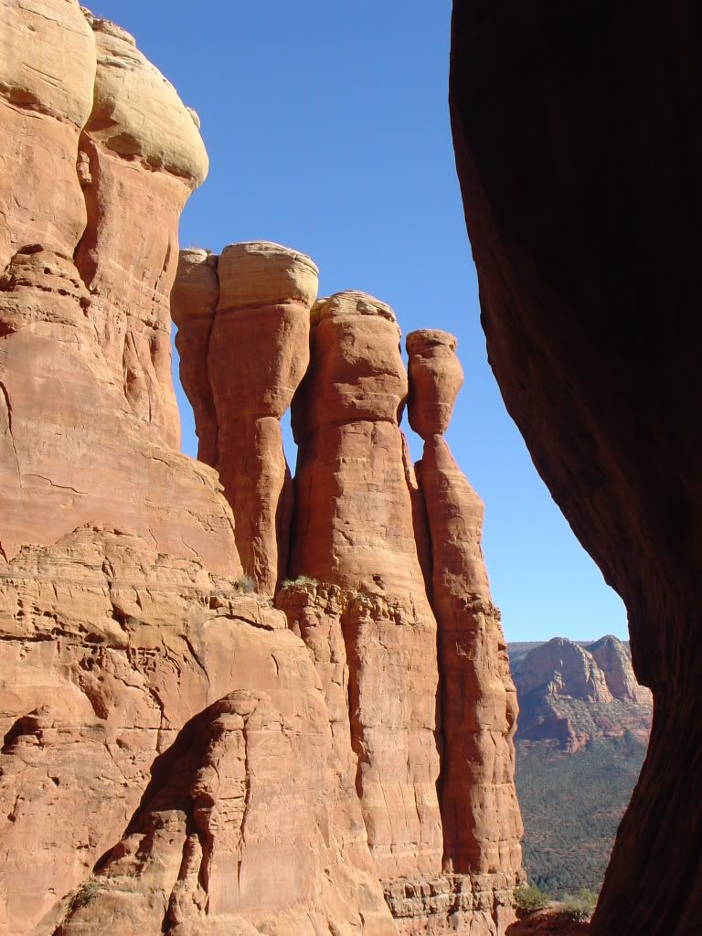
And sometimes you just have to laugh and stop and smell the flowers and take a picture of that nice rock arch even though you are in a middle of a race, because shit hasn't really gone right AT ALL and you paid money to do this and so you might as well enjoy it.
I think I am going to be haunted by this race for 365 days until I can go and try again. It was so completely frustrating while also being really memorable and fun in an adventurous 'lets spend 8 hours lost in a really beautiful place where there are apparently no checkpoints to be found' type of way.
Team ODP was coming off of a couple of solid finishes in the short sprint races over the summer and we really wanted to continue that trend. This was a longer ~30 mile race with real UTM navigation and orienteering so it was going to be a much bigger navigation challenge. We had only done one other longer race with this type of orienteering and had been less than impressed at our abilities to navigate/kayak a blow up banana. Now was our chance.
We drove up late Friday night to camp at the race start and despite the dark, I realized that the area was a little hillier than I was expecting. Looking at a topo map before, I was worried it was going to be all flat. We pulled into the site at midnight, Sarah set up a tent and Angel and I just crashed in the back of the wagon. We were up at 6 am after a night of tossing and turning where I dreamed that we were racing and got totally lost on navigation. We all laughed about my nightmare, confident that it wouldn't happen...

 These over-sized grasshoppers were everywhere...squashed all over the road, jumping onto us. They were multicolored and about 2.5 inches long. Gross.
I should have known thing weren't going our way when we realized that we had forgotten the keys to the bike rack and had to "break" out bikes out of the holder. Oops. Those locks aren't really that secure by the way. We were given the maps to the course about 5 min before the start and then had to run about 1/4 of a mile to get the coordinates.
 We plotted the first two trekking points and located them up in some mountains about 4 miles away. We took off down some dirt roads, and tried to find a steady pace that we could sustain for a far distance. People were blowing past us, but we knew better than to try to match their pace in this long of a race. We noticed most people heading up a trail towards the North side of the range, but Sarah said we were heading towards the South side so we would catch a road further south. We should have known better than to leave the pack, but we saw some teams still ahead of us on the road, so all was still good.
 After a couple of miles further, we came to the road we had been looking for and ran about a mile down it before coming up on a two person guy's team that we had been following. They were confused and seemed to think we were off. I looked at the map for the first time and realized that we were WAY off. We were south of the range that we wanted to be in the middle of. Shit. We had to backtrack 1.5 miles back the way we had come to even hit the right trail over to it.
 This is when everything proceeded to go wrong. By the time we got to the correct area (according to our plots) no one else was around. We stumbled upon the first point not exactly where we were expecting it, but not terribly far off so we just stamped our card and continued. Our next point had us bushwacking into a rough valley and up the mountain side to a finger ridge. I was concerned that we saw no one else since I figured any walkers should still be around, but oh well. We looked and looked and looked for that damn checkpoint to no avail. Replotted it, checked again, nothing. We saw people way to the north but thought they were taking a trail to the first CP we already had. We did find an awesome rock bridge which we took a picture by.
 After two hours of frustration, we gave up and headed back to the TA for the start of the biking completely devastated. How could we suck so bad at this nav stuff? I had a feeling that we were plotting the points wrong, but both Sarah and I couldn't not figure out the mistake in our current pissed off state. We had to head back to the TA for the bike transition without the CP because we were out of water and not making any progress.
 During our long run back to the TA (where we were passed by all the slow teams who were already on their bikes) we realized that we had lost the camera while bushwacking for two hour looking for the CP2. We decided that the camera was more important that any checkpoints and that we would go get our bikes and come back to look for the camera. After a long run back to the TA, we hung our heads and asked a guy running the TA for UTM help. He took a look at our points and claimed we were correct. Turns out he was wrong.
We jumped on the bikes and took off back to the damn mountain that we had just spent 2 hours on. Back into the bushwack. Back to the rock arch. I felt like we were looking for a needle in a haystack. I tried to remember our path and suddenly looked up and saw an orange camera hanging off the branch of a tree. It was a miracle. Our first bit of luck the whole day. We grabbed the camera and took off back to our bikes and down some fun downhill back onto the course to proceed with the race.We still didn't have CP2 but we decided to just proceed with the biking checkpoints.
It was now about 12:30 pm and I would guess we had at least 12 miles on foot all for only 1 found CP. But we did have 1 camera. We started towards the first biking CP and a nice man stopped in his truck to ask us if we needed help. I still didn't believe we were plotting right, and he proceeded to look at our maps and tell us we were completely off. We had screwed up the northing points which have 4 significant digits giving the right quantrant instead of three that we assumed. This put us a whole quadrant off for the first two points and the fact that we had found one was still just a lucky thing.
We finally were on the right track and only 5 hours into the race. Sweet. I am still frustrated because I know that we are still relatively new to this type of racing, but the time has come to figure it out and put it all together. I am tired of chalking things up to a learning experience. I want to learn from winning already. Okay, enough whining...
We took off with our points properly plotted and hit the first two CPs easily. We then started on a long climb up to the third one. It was at least four or five miles up a steep climb on a dirt road and through some rolling singletrack. The race cutoff was 3:00 and at 2:00 we realized that there was no way to make it all the way to the furthest point and back. We were told in advance that from CP3 to CP4 was a hike a bike down a dry river bed. From our current location, our best choice was to hike a bike a different dry river bed to another trail which would lead to CP4 and CP5 back at the TA.
I would have opted to do the whole thing late into the night if I had to but I realize that it isn't fair to the race organizers to just not show up at the finish. So we started the hike a bike which quickly turned into a lower your bike down over a 30 foot dry waterfall in sections to your friend. Wish we had taken a pic of this. It was obviously not a path the race organizers had chosen for us. We had some pretty hairy descents.
 Here Angel slides under a fence that cut across the canyon river bed.
We finally found a scant trail which we took towards CP4 and it eventually lead to an awesome singletrack ride back to the TA. We rolled back into the TA at 3:30 (30 min late) having successfully obtained 4 checkpoints in 7.5 hours out of the desired 10 CPs. Ridiculous. We didn't even turn our passport in. No point.
As far as post race assessment. It was a good training day :) Love it when people use that excuse. But it was actually. I felt really good at the end of 7.5 hours of running, bushwacking and biking and honestly, no bonk in sight. I was very proactive on keeping up with eating/drinking (at least until we ran out of water at the end). I forced a lot of calories and electrolytes early in the race and I think that made all the difference. So I will take that small victory and swallow my humiliation for our performance and underline this race for next year.
Oh and I will say that EVERYTHING from the accommodations, location, maps, swag, and raffle prices were top notch. Since the entry for this race is lower than most, it was most impressive. Go Gilmore go.


6 comments:
Haha - I like that one. I think it is about time you do some orienteering ;)
Yes. I have already looked up when some orienteering classes are. I need that compass around my neck to be more than just a fancy prop.
Go Gilmore Go Hannah Such a blog entry I just read Maybe a bike ride around the block would have been more fun! xxooMOM
Love your blog. Its so sweet it made me cry just now... Nothing in the world like a happy girl with a big smile on her face running around in the mighty American outdoors.
I was hoping you'd give an update on that knee. Its looking like you had a fairly impressive recovery.
~Suzan
Some of my best memorys are adventures turn epic when most all things went wrong and we made it out.
Good stuff
A comedy of errors. Reminds me of the Keystone Cops. Learn to read a map.
Post a Comment